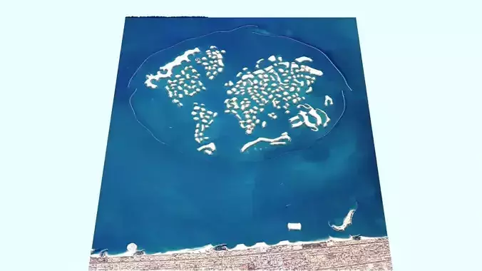
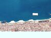
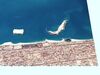
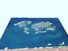
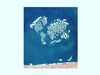
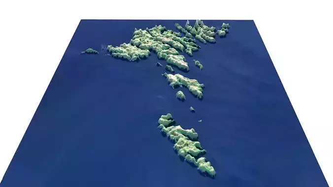
DescriptionWorld Map Island. World Map Island (The World Islands) (Arabic: جزر العالم, romanized: Juzur al-Ālam) are an archipelago of small artificial islands constructed in the shape of a world map, located in the Persian Gulf, off the coast of Dubai, United Arab Emirates. The World Islands are composed mainly of sand dredged from Dubai's shallow coastal waters and are one of several artificial island developments in the emirate. The World's developer is Nakheel Properties, and the project was originally conceived by Mohammed bin Rashid Al Maktoum, the ruler of Dubai. Construction was done by two Dutch joint-venture specialist companies, Van Oord and Boskalis, who also created the Palm Jumeirah. Construction of the 300 islands began in 2003, before being halted due to the 2008 financial crisis. Though 60% of the islands were sold to private contractors in 2008, development on most of the project has not started. As of July 2012, Lebanon Island was completed and was the only island that had so far been developed commercially, being used for private corporate events and public parties. As of late 2013, only two of the islands had been developed. In January 2014, Kleindienst Group announced the launch of the Heart of Europe project. By February 2014, JK Properties, one of Kleindienst Group's brands, announced that the project was well underway. The first of these series of islands will be Europe, Sweden, and Germany, with development led by Kleindienst Group. Islands in the project range from 1.4 to 4.2 hectares (3.5 to 10.4 acres) in area. Distances between islands average 100 metres (110 yd); they are constructed from 321 million cubic metres of sand and 386 million tons of rock. Designed by Creative Kingdom Dubai, the development is an area that covers 6 by 9 kilometres (3.2 by 4.9 nmi) and is surrounded by an oval-shaped breakwater island. Roughly 232 km (144 mi) of shoreline has been created. The World's overall development costs were estimated at $13 billion CAD in 2005. The archipelago consists of seven sets of islands, representing the continents of Europe, Africa, Asia, North America, South America, Antarctica, and Oceania. Each artificial island is named after its representative country, landmark, or region, such as France, California, Rio de Janeiro, Mount Everest, Australia, New Mexico, Upernavik, Buenos Aires, New York, Mexico, Saint Petersburg, São Paulo and India. The project was unveiled in May 2003 by Al Maktoum and dredging began four months later. By January 2008, 60% of the islands were sold, with 20 being bought in the first four months of 2007. On 10 January 2008, the final stone on the breakwater was laid, completing development of the archipelago. As of July 2012, a second island, the Lebanon Island (1.5 hectares, or 3.7 acres and 482.21 metres of perimeter) was developed and was 'the only island that has so far been developed commercially, is used for private corporate events and public parties'. The Times reported in September 2009 that work on the World had been suspended due to the effects of the 2008 financial crisis. Nakheel denied 2010 reports that the islands were sinking into the sea as wholly inaccurate. Despite the denial, The Daily Telegraph reported in January 2011 that an independent company, Penguin Marine, provided verification on the erosion of the islands and the silting of the passageways between the islands. Due to financial and technical problems, Penguin Marine, contracted to provide transportation to the archipelago, attempted to get out of the annual fees of $1.6 million paid to Nakheel properties. Until early 2012, only one of the islands had been occupied by a building (a show home) and commercial or residential properties were not being constructed on any of the other islands. Property prices in the Emirates had fallen 58% from their peak in the fourth quarter of 2008. The world economic recovery from the Great Recession resulted in a rebound for the Dubai real estate market: it was reported that residential prices [in Dubai] rose by 17.9% from August 2012 to 2013, while rents soared by 14.9% in the same period.
Texture Resolution: 1814 x 2383