1/12
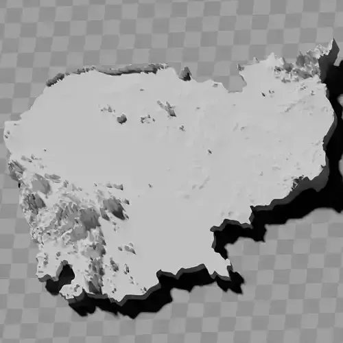
Cambodia relief map collection / geography kit
Note that some of the mountains have been truncated
Includes several models:
a cutout with exaggerated terrain / topography [Mercator-projection-distorted version + undistorted version]
simplified version(s) with reduced polygon counts via quadratic decimation
non-cutout versions of the tolopgy [Mercator-projection-distorted version + undistorted version]
a simple 'prism' [flat-surfaced cutout of the country's boundaries with no topology features added]
'expanded' version which is a convex hull of the prism. You can use this as a 'base' to stabilize the model to avoid problems with small details breaking off if you try to 3d print it.
includes STL and OBJ formats. non-textured.
~~~~~~~~~~~~~~~~~~~~~~~~~~~~~~~~~~~~~~~~~~
ប្រមូលផ្តុំផែនទីជម្រាលកម្ពុជា / ឧបករណ៍ភូមិសាស្ត្រសូមកត់សម្គាល់ថាភ្នំមួយចំនួនត្រូវបានកាត់ខ្លីរួមបញ្ចូលគំរូជាច្រើន៖ការកាត់ដោយមានភូមិសណ្ឋាន / ភូមិសាស្ត្រដែលបានពង្រីក [កំណែបែកទ្រង់ទ្រាយ Mercator + កំណែមិនបែកទ្រង់ទ្រាយ]កំណែដែលបានសម្រួល ដោយមានចំនួនពហុកោណកាត់បន្ថយតាមរយៈការកាត់បន្ថយចតុកោណកំណែមិនកាត់នៃភូមិសាស្ត្រ [កំណែបែកទ្រង់ទ្រាយ Mercator + កំណែមិនបែកទ្រង់ទ្រាយ]'ប្រីស្ម' សាមញ្ញ [ការកាត់ផ្ទៃរាបនៃព្រំដែនប្រទេសដោយមិនបន្ថែមលក្ខណៈភូមិសាស្ត្រ]កំណែ 'ពង្រីក' ដែលជាសំបកត្រួតស៊ីគ្នានៃប្រីស្ម។ អ្នកអាចប្រើវាជា 'មូលដ្ឋាន' ដើម្បីធ្វើឱ្យគំរូមានស្ថិរភាព ដើម្បីជៀសវាងបញ្ហាផ្នែកតូចៗបែកចេញនៅពេលអ្នកព្យាយាមបោះពុម្ព 3D។រួមបញ្ចូលទម្រង់ STL និង OBJ។ គ្មានវាយនភាព។
REVIEWS & COMMENTS
accuracy, and usability.


