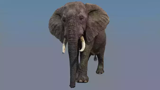
San Francisco Low-poly 3D model
This is exact and accurate to scale 3D city model of San Francisco, California and its surrounding area based on GIS data (March 2021)
- File units: Meters
- Scale: 1:1
NO MISSING BUILDINGS!
- This is the only product on the market with 100% buildings coverage from 125,192,184 buildings footprint polygon geometries in all 50 U.S. States
PACKAGE CONTENTS
- Fully customizable - you can select only the options you need!
- This product includes scenes of various sizes / formats
- 20 x 20 km - Full city extents
- 15 x 15 km - San Francisco International Airport - SFO
- Any custom area size (please request before buying)
- FORMATS INCLUDED
- MAX - Autodesk 3dsMax
- FBX, OBJ, DAE - Exchange Formats
- GLTF, GLB - Games, Web, AR/VR (request)
- UNITYPACKAGE - Unity 3D
- 3DM - Rhino 3D
- SKP - SketchUp
- RVT, RFA - Autodesk Revit
- STL - 3D Print (request)
- C4D - Cinema4D
- BLEND - Blender
- MA, MB - Autodesk Maya
- DWG, DXF - Autodesk AutoCAD
PRODUCT INFO
-
KEY BENEFITS
- Live 24/7 support (custom requests, adjustments and updates)
- Buildings, landuse areas, roads and railways split by type (see scene structure)
- The surface is flat, easy to add details and edit geometry (terrain on request)
- Realistic low-poly trees and forests (max, fbx included, other formats by request)
- Product is ready to render out-of-the-box (3dsmax + corona renderer)
-
TOPOGRAPHY TERRAIN (not included, please request before buying)
- Up to 5 meters accuracy raw terrain object (2001-2015 LiDAR survey)
- Multiple LODs optimized to achieve perfect polycount/details balance
- High-resolution (up to 128K) sattelite or surface texture applied
- Buildings and roads placed on the optimized terrain
-
OTHER EXTRAS (for a surcharge, please request before buying)
- Crop to custom area size or slice to tiles
- Procedural textures assigned to all buildings
- Individual buildings and streets (with address and/or name)
- Any coordinate system (Transverse Mercator projection by defaut)
- Administrative boundaries of all levels (named polygons or outlines)
- Road and railway splines for traffic animation
- Public transport stops with names
-
PRESENTATION IMAGES
- 4K high-resolution realistic renderings (refer to images for level of detail)
- Rendered in 3dsMax (other softwares requires its own rendering settings)
-
MATERIALS
- Buildings are UVW mapped, split by material IDs, no textures assigned
- Trees, vegetation, landuse and airport surface with the textures assigned
SCENE STRUCTURE (layers / named objects split by type)
- BUILDINGS
- residential
- commercial
- industrial
- public
- sports
- parkings
- transport
- ROADS
- highways
- primary
- secondary
- tertiary
- residential
- service
- RAILWAYS
- train
- city tram
- subway
- monorail
- PAVEMENT
- sidewalk
- footway
- cycleway
- LANDUSE
- residential
- public
- industrial
- construction
- agriculture
- VEGETATION
- forest
- grass
- scrub
- park
- garden
- cemetery
- recreation
- NATURAL
- land
- sea
- lake
- river
- AIRPORT
- building (terminal, gates)
- apron
- taxiway
- runway
SUPPORT - please send us a message 24/7
- FREE - Product update with the latest GIS data (please request before the purchase)
- $299+ - Topography terrain add-on
- Unbelievable!
- Nice model
- great
- I really like it
- We really love your works
This product has no reviews yet