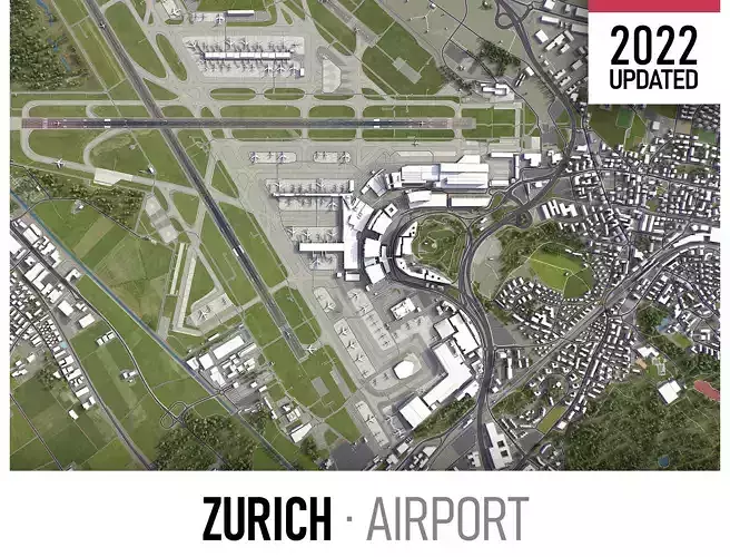
DESCRIPTION
  • Coordinate reference system: WGS 84 / UTM zone 32N (EPSG:32632)
  • Scene size: 12 x 12 km
  • Units: Meters
  • Scale: 1 : 1
  • Data used: November 2022
  • SEND US A MESSAGE BEFORE YOU BUY
    • Get FREE sample model - www.each.city/sample
    • Customization requests
      • Any scene size (custom area crop)
      • Any coordinate reference system
      • Various levels of detail (LODs)
      • Update to the latest data
    • Flexible pricing (select only the options you need)
  • PACKAGE CONTENTS
    • This product includes scenes of various sizes and formats
    • File formats (software supported)
      • MAX - Autodesk 3dsMax
      • FBX, OBJ, DAE - Exchange Formats
      • GLTF, GLB - Games, Web, AR/VR (request)
      • UNITYPACKAGE - Unity 3D
      • 3DM - Rhino 3D
      • SKP - SketchUp
      • RVT - Autodesk Revit (request)
      • STL - 3D Print (request)
      • C4D - Cinema4D
      • BLEND - Blender
      • MA, MB - Autodesk Maya
      • DWG, DXF - Autodesk AutoCAD
  • BASIC OPTIONS (included with the purchase)
    • KEY BENEFITS
      • 24/7 customer support
      • High-resolution surface texture (1 meter resolution satellite image)
      • Buildings, landuse areas, roads and railways split by type (layers / named objects)
      • The surface is flat, easy to add details and edit geometry
      • Realistic low-poly trees, forests and airplanes (max, fbx included, other formats on request)
      • Product is ready to render out-of-the-box (3ds Max + Corona Renderer)
    • PRESENTATION IMAGES
      • 4K high-resolution realistic renderings (refer to images for level of detail or request close-ups)
      • Rendered in 3dsMax (other software requires its own rendering settings)
    • MATERIALS
      • Trees, vegetation, landuse and airport surface with the textures assigned
      • Buildings are UVW mapped, split by material IDs, no textures assigned
  • CUSTOM OPTIONS (available at a special price - please request before buying)
    • TOPOGRAPHY TERRAIN
      • Up to 1 meter accuracy raw terrain object (USGS 3D Elevation Program)
      • Multiple LODs optimized for the best polycount/details balance
      • Contour lines (up to 1 meter interval)
      • High-resolution (up to 20cm accuracy) satellite or surface texture
      • Buildings and roads placed on the optimized terrain
    • OTHER EXTRAS
      • On-demand custom update
      • Crop to custom area size or slice to tiles
      • Procedural textures assigned to all buildings
      • Individual buildings and streets (with address and/or name)
      • Road, railway and airways splines for traffic animation

REVIEWS & COMMENTS

See what other buyers think about this model - real feedback on quality,
accuracy, and usability.
wh
whitehouseCommunity member
This user is part of the CGTrader community
m

Zurich Airport Low-poly 3D model

Royalty Free License
Hire
Like this model to show appreciation to the designer.
See how many times this model was viewed.
Share this model to support the designer and boost their visibility.
Native file format
MAX3 files
Size: 110 MB
Exchange formats
BLEND
Blender<br />File Size: 25.2 MB
OBJ
OBJ<br />File Size: 26.7 MB
FBX
Autodesk FBX | 2 files<br />File Size: 60.6 MB
C4D
Cinema 4D<br />File Size: 25.1 MB
MA
Autodesk Maya<br />File Size: 33.1 MB
GLTF
glTF<br />File Size: 20.4 MB
UNITYPACKAGE
Unity 3D<br />File Size: 72 MB
3DM
Rhinoceros 3D<br />File Size: 60.2 MB
SKP
Sketchup<br />File Size: 61.6 MB
DAE
Collada<br />File Size: 44.4 MB
DWG
AutoCAD<br />File Size: 30.2 MB
DXF
DXF<br />File Size: 38.2 MB
Provided by designer
Information and details shared directly by the model's designer.
3D Features
The model includes animations (movement or actions) that can be played in supported software or engines.
The model has a skeleton or bone structure, making it ready for posing or animation.
PBR
Uses Physically Based Rendering materials, which give the model realistic lighting and surface properties.
Textures
The model includes image files (textures) that add color, patterns, or detail to its surfaces.
Materials
The model has material settings that define how surfaces look (color, shine, transparency, etc.).
UV Mapping
The model's surfaces are mapped to a 2D image, allowing textures to display correctly.
Plugins Used
Some external plugins were used to create the model. These may be required for full functionality.
3D printing
Indicates whether the designer marked this model as suitable for 3D printing.
Model is not 3D printable
The designer indicates this model is intended for digital use only (rendering, animation, or AR/VR) and not for 3D printing.
Geometry
Polygon mesh
A model built from polygons (triangles or quads) connected in a mesh.
1 polygons
The total number of polygons (flat shapes) that make up the 3D model.
/ 1 vertices
The number of points (corners) that define the shape of the model's polygons.
Unwrapped UVs
Publish date
Model ID
Chat