
Useto navigate. Pressescto quit
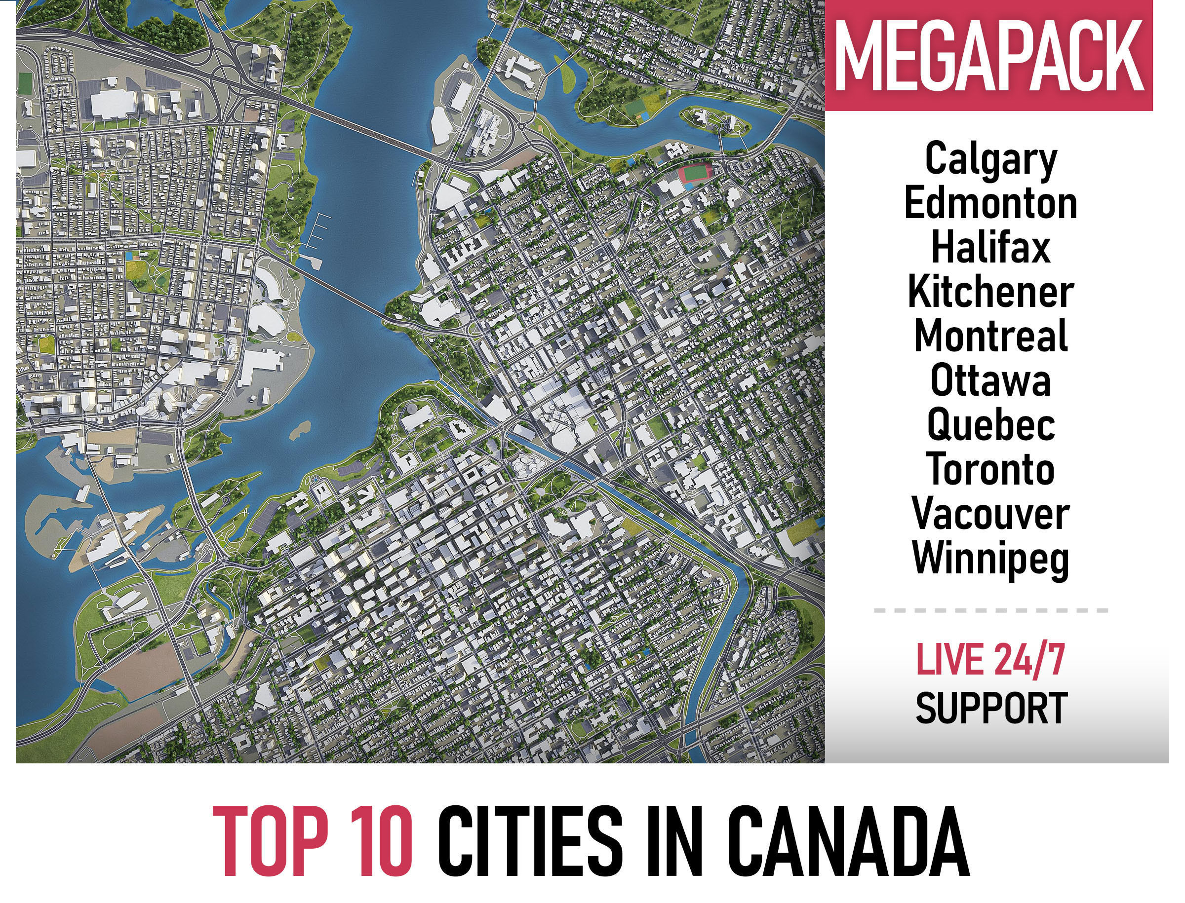
Top 10 Cities in Canada MEGAPACK 3D Model Collection
Description
Collection of the Top 10 Canadian cities with the surrounding area based on GIS data (May 2020)
The only product on the market with 100% 3d buildings coverage from 12,663,475 buildings footprint polygon geometries in all canadian provinces and territories
- Projections: Transverse Mercator
- File units: Meters
COLLECTION
- Calgary
- Edmonton
- Halifax
- Kitchener
- Montreal
- Ottawa
- Quebec
- Totonto
- Vancouver
- Winnipeg
PRODUCT INFO
- KEY BENEFITS
- Live 24/7 support (format conversion, software adjustment, area cropping, etc.)
- This 3D city model is georeferenced, exact and accurate to real-world scale
- Buildings, landuse areas, roads and railways split by type (see scene structure)
- The surface is flat, easy to add details and edit geometry (terrain on request)
- Realistic low-poly trees and forests
- EXTRAS (on request)
- Administrative boundaries of all levels (named polygons or outlines)
- Road and railway splines for traffic animation
- Public transport stops with names
- PRESENTATION IMAGES
- Product is ready to render out-of-the-box (3dsmax + corona renderer)
- 4K high-resolution realistic renderings (refer to images for level of detail)
- MATERIALS
- Buildings are UVW mapped, split by material IDs, no textures assigned
- Trees, vegetation, landuse and airport surface with the textures assigned
SCENE STRUCTURE - model is organized by layers, all objects split by type and named properly
- BUILDINGS
- residential
- commercial
- industrial
- public
- sports
- parkings
- transport
- ROADS
- highways
- primary
- secondary
- tertiary
- residential
- service
- RAILWAYS
- train
- city tram
- subway
- monorail
- PAVEMENT
- sidewalk
- footway
- cycleway
- LANDUSE
- residential
- public
- industrial
- construction
- agriculture
- VEGETATION
- forest
- grass
- scrub
- park
- garden
- cemetery
- recreation
- NATURAL
- land
- sea
- lake
- river
- AIRPORT
- building (terminal, gates)
- apron
- taxiway
- runway
SUPPORT - please send us a message 24/7
- FREE - Product update with the latest GIS data
- $299+ - Request any other city or area (same day delivery)
- $199+ - Add terrain based on SRTM or LIDAR elevation data (3-5 LODs optimized)
Top 10 Cities in Canada MEGAPACK
Royalty Free License
Top 10 Cities in Canada MEGAPACK
Royalty Free License

3D Collection formats
Format limitations
- Autodesk FBX(.fbx) 6/6
- Autodesk 3ds Max(.max) 6/6
- Sketchup(.skp) 6/6
- OBJ(.obj) 6/6
- OBJ(.mtl) 6/6
- Rhinoceros 3D(.3dm) 6/6
- Unity 3D(.unitypackage) 6/6
- Unity 3D(.prefab) 6/6
- Blender(.blend) 6/6
- PDF(.pdf) 4/6
- 3D Studio(.3ds) 4/6
- Cinema 4D(.c4d) 6/6
- Collada(.dae) 6/6
- DXF(.dxf) 6/6
- glTF(.gltf) 4/6
- glTF(.glb) 4/6
- Lumion(.ls10) 4/6
- Autodesk Maya(.ma) 6/6
- Autodesk Maya(.mb) 6/6
- Autodesk Revit(.rfa) 4/6
- Autodesk Revit(.rvt) 4/6
- Stereolithography(.stl) 4/6
- UnrealEngine(.uasset) 4/6
- AutoCAD(.dwg) 5/6
- fbm(.fbm) 1/6
3D Collection details
- Publish date2018-10-08
- Collection ID#1009152
- Animated 0/6
- Rigged 0/6
- VR / AR / Low-poly 6/6
- PBR 6/6
- Ready for 3D Printing
Similar VR / AR / Low poly 3D Models
to Top 10 Cities in Canada MEGAPACK low-poly 3d model

