Top 3 Cities in Australia

Top 3 Cities in Australia 3D Model Collection

The collection consists of:8 models total
3D Model
Low-poly
PBR
.rfa
.3ds
.dwg
.fbx
.c4d
.dxf
.ma
.mb
.obj
.3dm
.skp
.max
.blend
.dae
.rvt
.stl
.mtl
.unitypackage
.uasset
.prefab
.pdf
.gltf
.glb
.ls10


Description

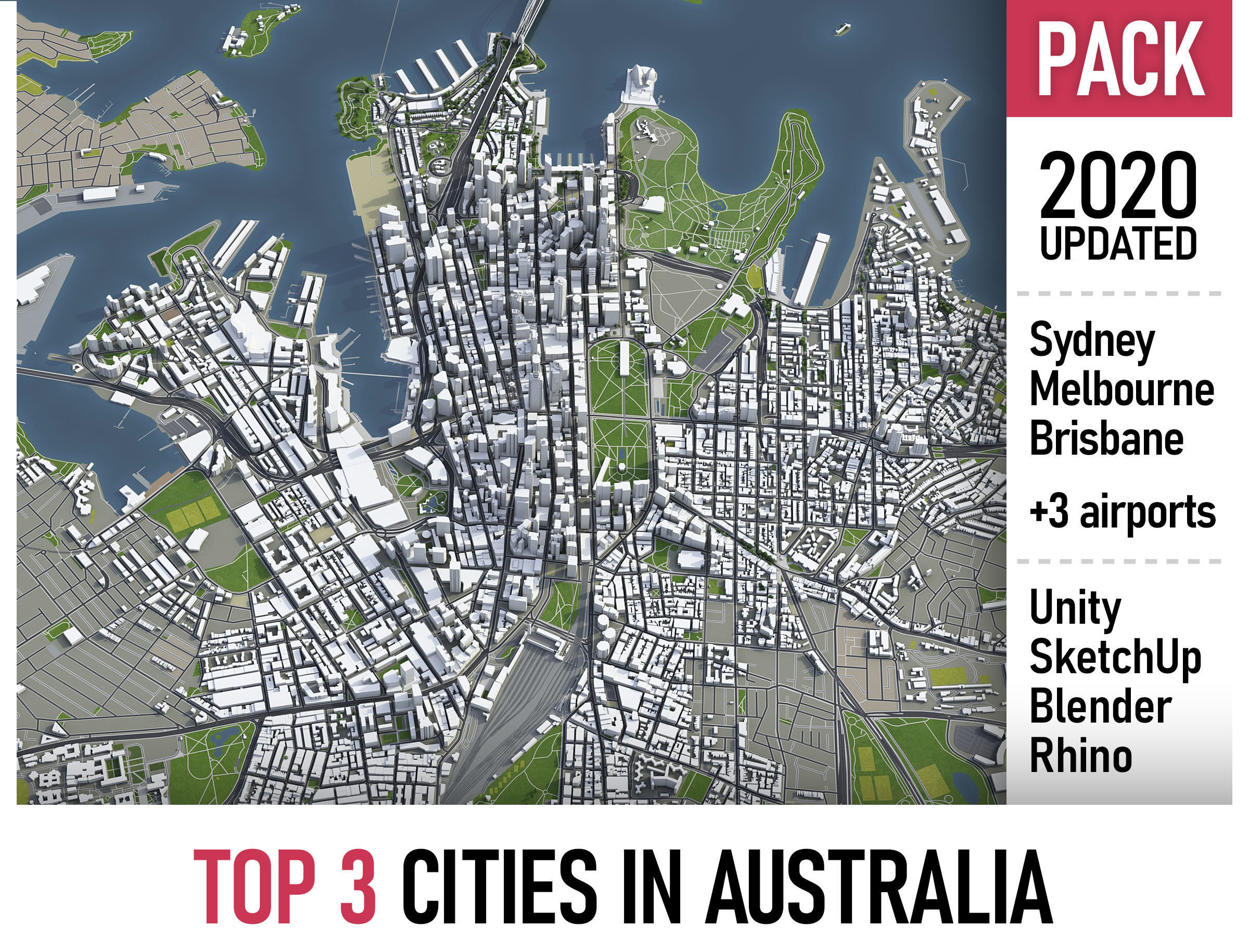
This is exact and accurate to scale Australian 3D city models based on GIS data (July 2019)

  • Georeferencing: Transverse Mercator projection
  • File units: Meters
  • Scale: 1:1

COLLECTION

  • Brisbane
  • Melbourne
  • Syndney

FORMATS

  • MAX - 3dsMax (V-Ray and Standard materials)
  • FBX, OBJ, DAE - Exchange Formats
  • UNITYPACKAGE - Unity 3D
  • BLEND - Blender
  • SKP - SketchUp
  • JPG - Realistic renderings (4K or 8K resolution)

KEY BENEFITS

  • This 3D city model is georeferenced, exact and accurate to real-world scale
  • Transverse Mercator projection delivers high accuracy within each UTM zone
  • The complete city within administrative boundaries and its surrounding area
  • Buildings, landuse areas, roads and railways split by type
  • Realistic low-poly trees (in a separate file/layer)

SCENE STRUCTURE - model is organized by layers, all objects split by type and named properly

  • BUILDINGS
    • residential
    • detached houses
    • commercial
    • industrial
    • educational
    • public
    • sports
    • parkings
    • transport
    • religious
    • unclassified
  • ROADS
    • highways
    • primary
    • secondary
    • tertiary
    • residential
    • service
  • RAILWAYS
    • high-speed train
    • city tram
    • subway
    • monorail
    • construction
    • abandoned
  • PAVEMENT
    • pedestrian
    • sidewalk
    • paths
    • cycleway
  • LANDUSE
    • residential
    • rural
    • public
    • industrial
    • construction
    • agriculture
  • VEGETATION
    • forest
    • grass
    • scrub
    • park
    • garden
    • cemetery
    • recreation
  • LAND
    • land
    • sand
    • ground
    • wetland
  • WATER
    • coast
    • lake
    • river
    • stream
  • AIRPORT
    • building (terminal, gates)
    • apron
    • taxiway
    • runway
    • marking

SUPPORT - please send us a message 24/7

  • FREE - Product update with the latest GIS data
  • ASK - Request any other city or area (same day delivery)
  • $99 - Terrain based on SRTM or LIDAR elevation data (3-5 LODs optimized)
  • $49 - High-resolution satellite image (up to 32000x32000px, with georeferencing)
lhnm
lhnm 2020-08-07 15:50:45 UTC
Great work!
Item rating
0 0
Top 3 Cities in Australia
$1,499.00
 
Royalty Free License 
Top 3 Cities in Australia
$1,499.00
 
Royalty Free License 
Response 99% in 0.1h
3D Modeling
Low-poly Modeling
UV mapping
Hire me

3D Collection formats

Format limitations
  • Sketchup(.skp) 5/5
  • Rhinoceros 3D(.3dm) 5/5
  • Cinema 4D(.c4d) 5/5
  • Autodesk Maya(.ma) 5/5
  • Autodesk Maya(.mb) 5/5
  • Autodesk FBX(.fbx) 5/5
  • Unity 3D(.unitypackage) 5/5
  • Unity 3D(.prefab) 5/5
  • Autodesk 3ds Max(.max) 5/5
  • AutoCAD(.dwg) 5/5
  • Collada(.dae) 5/5
  • OBJ(.obj) 4/5
  • OBJ(.mtl) 4/5
  • Blender(.blend) 5/5
  • DXF(.dxf) 4/5
  • Autodesk Revit(.rfa) 4/5
  • Autodesk Revit(.rvt) 4/5
  • PDF(.pdf) 4/5
  • 3D Studio(.3ds) 4/5
  • glTF(.gltf) 4/5
  • glTF(.glb) 4/5
  • Lumion(.ls10) 4/5
  • Stereolithography(.stl) 4/5
  • UnrealEngine(.uasset) 4/5

3D Collection details

  • Publish date2018-10-08
  • Collection ID#1008569
  • Animated 0/5
  • Rigged 0/5
  • VR / AR / Low-poly 5/5
  • PBR 5/5
  • Ready for 3D Printing
Help
Chat